A Day Of Contradictions.
The Longest Day ..... 70 miles (I ended up with 72)
Today was not the kind of day that you would expect from a rail trail..... no, not at all. Oh, it started out normally enough, up at 5:00am, break camp, get everything put away. Gee....somehow I sure wish I'd been more organized the night before. In the dark at 5am is not the time to be trying to find your light that you should have taken out before you went to bed. So, I ended up trying to put everything away, and find my today's riding clothes all in the dark. I can guarantee you, this only happened one morning! I had to put it away wet because literally every morning there was a very heavy wet dew that covered everything almost like rain. I did finally get everything put away, and headed over to the gym that was set up for our meetings and meals, to get in line for breakfast. Once again, I was impressed at how fast the line moved, and before you know it, I was dishing up my plate. I was hungry, but the breakfast wasn't quite up to what I'd begun to expect ...... fresh fruit, (the best part) a hash brown potato casserole, some kind of baked cheesy stuff, a Krispy Kreme donut, or sweet roll (choice), juice, and coffee. It was OK and fresh, just not my normal type of breakfast. Anyway, breakfast over..... time to get on the trail at 6:30am, Bye, Liberty Park........

Back on the trail, I thought maybe I must have taken some kind of super vitamin this morning, Maybe it was the Krispy Kreme? At any rate, I was really fast! Getting under way this morning at 16-18mph! WOW! This was going to be a fast 70 miles ...... wait..... why am I now only going 9mph, and struggling. After 20 more minutes of struggling along at 9-10mph, suddenly, I managed to gain strength again, and was once again going 16-18 and sometimes even saw 20mph. Five minutes of this, and I was back to 9mph again. Hmmmmm ..... Finally, I realized, I could look ahead and see an uphill grade ...... not a real hill like you would think, but just a steady uphill grade. This, for trains, would have been a series of rollers, but for a bicyclists, it was just long uphills followed by long, but quick downhills. Plus, for the second day in a row, our wind was once again from the NE, right into us. The route between Sedalia and Boonville was the hilliest on the entire trail, a steady series of ups and downs no matter which way you run the trail. It was, however, a very pretty section of the route.

There were many, many bridges along the trail. I love old truss bridges, but I soon tired of taking pictures of them as there were so many all along the trail.

Bridges over streams like this one......

One of several more or less complete (but inoperative) railroad semaphore signals .

On some areas of today's ride, there were open spaces where you get a glimpse of the surrounding countryside, like this pastoral farm scene.

And finally, into Boonville.

Only a very few of these trail heads like this one had water and flush toilets. Most had pit toilets, and no water. For those of you that are planning on doing the trip on your own, I would caution you to plan carefully. Water can be a real problem, stores and cafes keep their own hours, maybe not so convenient for you, but for them. Camping is not so easy to find either, and all (literally) the land on either side of the trail is private ....NO trespassing. It can certainly be done on your own, just be sure you plan carefully. Plan the ride, and ride the plan! The nice part about doing the trail with the State Park was that they took all the problems away, and all you had to worry about was pedalling and getting your mileage in. So far, the first two days of the trail you could easily ride this with any bike you brought, A road bike with 700/23's.....no problem, a tourer or hybrid with 700/35's .... no problem, mountain bike...... no problem. Run what you brung is the order of the day!. That said, it wasn't all like that. Later today will give me good reason to be glad I chose the mountain bike, and there will be several more times I found myself saying that. Almost everyone could benefit from Kevlar liners in the tires also, as I was to find out later. Kevlar belts ain't enough!
Boonville had a nicely restored depot, and a very nice Katy caboose in the original color scheme.


Both the station (gift shop) and the caboose (mini-museum) were open for viewing. This one was very nice inside.


I've always wanted to sit up in the cupola of a caboose, and this one was open with no signs to the contrary, so I slipped off my riding shoes and climbed the steps up and sat in the chair. This is the view..... first toward the front.....

and then over to the other side. The chairs face opposite one another so you could face the front of the train no matter which direction the caboose was hooked up. Can't just turn one of these around just anywhere.

The original Katy logo ...... The railroad's name came from shortening the Missouri, Kansas, Texas Railroad to just the initials MKT and later, the "M" was dropped and it became the KT ...Katy...

Anyway, onward from Boonville, headed for Columbia, the trail became flat and tedious. The day was getting quite warm, and the miles were wearing on me. The surface of this trail drags on your tires and adds to the tedium. Leaving Boonville, we crossed the Missouri for the first time, over a very nice dedicated bike lane attached to the southbound side of the highway bridge.

And....looking upstream from the bridge, was the old Katy lift span bridge for the railroad. They are trying to gather up enough donations to save the bridge, although, I think anyway, it won't happen. Because of river barge traffic, the bridge would have to be in restored working condition ... quite a large expense, then maintained in that condition, and manned 24/7. A lot of expense for a bunch of bicyclists. Anyway, it's still here as of now....... a unique bit of history.......

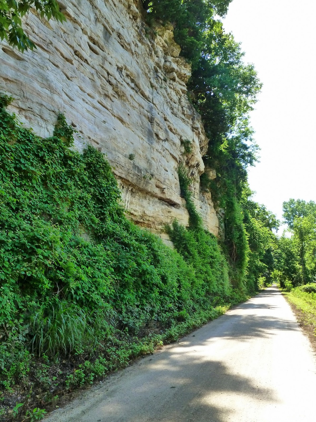
I caught up with the young man crossing the bridge with the panniers on his bike (in the photo above), and we rode together and chatted for a while. He was doing the trail alone, not with our group and staying with friends along the way to St Louis. Loaded light (not camping), he said if he knew about this organized ride, he wouldn't be riding it alone. He had already found some difficulties finding food and water on some parts of the trail. We rode together for about 45 minutes and he had to stop as he was having some leg cramping. So I bade him farewell, and continued on toward Rocheport. He did let me know that Rocheport had a good place to eat, and I was ready for lunch. This part of the ride was the first of the limestone cliffs that would be our companion for most of the rest of the way.
After many miles of this kind of riding, we came to the only tunnel on the route, the Rocheport tunnel. I took the picture from the wrong side, as the eastern portal is more scenic, but here is what I got.....

Just on the other side of the tunnel is the town of Rocheport.

A very quaint little town, not many people except today. Hardly any motor vehicle traffic to worry about here, and no need to lock your bike. There's mine behind the light pole. The building right behind my bike is the Rocheport General Store. Sandwiches and ice cold beer. When they're open. Today they were! He also was nice enough to ice my water bottles for free. The inside is like stepping back in time. At one time it was the town drug store and soda fountain, and there are several reminders of that. Makes me think of the drug stores of my youth.


Not a big food selection, deli style sandwiches, but they were good, and the beer was COLD..... and that was that! Feeling much better about everything after an hour sitting there talking with some of the other riders that showed up, and no longer feeling hungry, I pushed onward, following the path (backwards) of those other explorers, Lewis and Clark. Still headed to Columbia. The river is our companion on the right hand side, and the limestone cliffs on the left.

Along the trail was a cave purported to be used by Lewis and Clark. It's a hole in the rock......

Finally a rest stop down the way at Hindman Junction, I really wasn't going to stop, but thought I would anyway. Stopped and rinsed my bottle out that had Gatorade in it, and replaced with plain water. It was getting too hot for Gatorade, and it was making me feel a bit ill. I asked the lady at the rest stop how much further the turn off was for the Columbia Spur, and she replied ....."Why it's right behind you"..... What? I would have missed it completely as it takes off in a northwesterly direction, only later curving back around to the east. I didn't even see it at all. No signs either. If I hadn't asked, I'd have spent a lonely uncomfortable night somewhere. This trail is quite a bit different than the main trail, very loose in spots with deep loose crushed rock in some areas. It made for hard pedalling, and tricky handling. At least one person fell on this section, it wouldn't be hard to do. Besides being loose, it was twisting and winding, a pleasant change from the straight as an arrow Katy mainline.

A little further on down the road, I realized that I hadn't seen any other riders for a while, and had fears that maybe I'd missed a turn somewhere, so I stopped for a bit to see what came up the trail, on this cool little bridge.

I stopped a rider coming the other way and asked him if he'd seen many riders going the other way. He replied that he hadn't. Just about that time, Kathy goes by (the gal with the crescent saddle) and the fellow said...... "why not follow her", so I told him I'd follow her even if she did lead me astray. But, she didn't, she led me right to the campground. Lucky me to have such good friends to take care of the old man. We did have a pretty little hill to climb, and the next morning I got a picture of it going back down. Steep, switchbacks up and over a ridge. Then it was surface streets to the school where we camped. I thought I was so late.....but there mustn't have been half a dozen riders there when I got there. It was a long day after all. Kathy and I found a nice shady spot to set up our tents, and along came Kelley and Rob after we had been there about an hour, and they set up with us. Here's Kelley and Rob...... my Peculiar friends....... You will see a lot more of them in the days to come.

Yeah...my Peculiar friends.....hmmmmmm wait....... that's just not right, it's not my friends who are peculiar, it's their town..... Well, no, that just doesn't sound right either ..... well anyway, they were from Peculiar, MO, a little town just south of Kansas City ..... there, that's better. When I mentioned that Missouri people often had a bit different way of pronouncing names, she said yeah, she liked to say "Peck-you-liar"...... OK.... chuckle, laugh even..... A good example of this is the town of Nevada, MO.... it's not pronounced like the state that Las Vegas resides in, it's pronounced Nev-AY-dah. They were the nicest couple and we had so much fun together the rest of the trip. Because there were no facilities big enough for our group at this school, dinner at Columbia was a ten dollar gift card to any of the restaurants in "The District"..... a funky little downtown area that people from San Francisco would love. Lots of little lost art shops, and cute stores, and many, many restaurants. We chose the Flatbranch Pub and Brewery. I had a taco salad, that turned out to be much more salad than taco, but it was good anyway. Two big (18 ounce) mugs of ice cold Katy Trail Pale Ale to wash it down, that was GREAT! Smooth silky, and easy on the palate, and ice cold. Just what the doctor ordered. This was turning into a great stop. Good friends, good food, fun conversation, and great beer..... what could be better! They took us downtown in a shuttle bus, and brought us back the same way. After we left the restaurant, we weren't sure where the shuttle stopped, so I suggested we walk the block back to where it dropped us off, and, as luck would have it, it pulled up just as we got there. Talk about good service! Our riders meeting was late that night, and by the time that was over, and we chatted for a bit more in the evening, between the miles travelled, the food, the beer, and the time of night, I could hardly hold my eyes open. So I bade farewell to my friends, and promised them.... tomorrow we ride! And that, my friends is another story!
I don't know Richard.....Looks like day two was a huge success! A good challenging ride, good lunch stop and a great time for the dinner hour with new friends and good food and good beer! Good people tend to draw to each other, it was cool that you found some new people to become friends with!
ReplyDeleteMissing the turn would have been bad, or at least a lot of back tracking riding!
Looking forward to day three!!
I get it: The KATY Trail is a former Railway track, prepared for cyclists! And THAT in America! Nice pictures, (henk engbers).
ReplyDeletePosting this pretty late, just wanted you to know how much I am enjoying your comments and great pictures. They are good prep for the trip we are planning in October 2015. Have you linked this blog to the Katy Trail website? It's just what people want to see as they plan their trips. Thanks!
ReplyDeletehttp://www.bikekatytrail.com/default.aspx