Tuesday, August 26, 2014

The Thin Gray Line


August 26, 2014

The Thin Gray Line

Look at a map, even the most detailed maps and you will find lines running across the page, red ones, blue ones, yellow ones, black ones and gray ones. If the map is well detailed, you may even find thin gray lines, or even ones with the thinnest double gray lines, or maybe, if the map is really detailed, a dashed gray line. The big red and yellow lines are the fastest way between two points .... big expensive, heavily travelled multi-laned highways. These usually connect big cities together, and slide right on by the tiny little towns and villages along the way. These are for people who want to put a lot of miles behind themselves from morning until night. The black lines and small blue lines, are for secondary roads, those little roads of yesterday that connect all the little towns and local people like a connect the dots game. Then there are the wider gray lines, still local roads, mostly paved that locals depend on more than tourists. Then ..... there are the adventure roads ..... the tiniest little gray single and double dashed lines on the most detailed of maps. These are where the real adventure lies. There may even be some that only local people know about and pass from one to another by word of mouth. These are not the kind of roads one seeks while in a car, but a bicycle is perfect. Go back 100 years, and this was the kind of roads bicycles were primarily used for. Once in a while you find a real gem, like this one in southern Lincoln County, Oklahoma. This one, you won't find on any map, except for Google Earth.
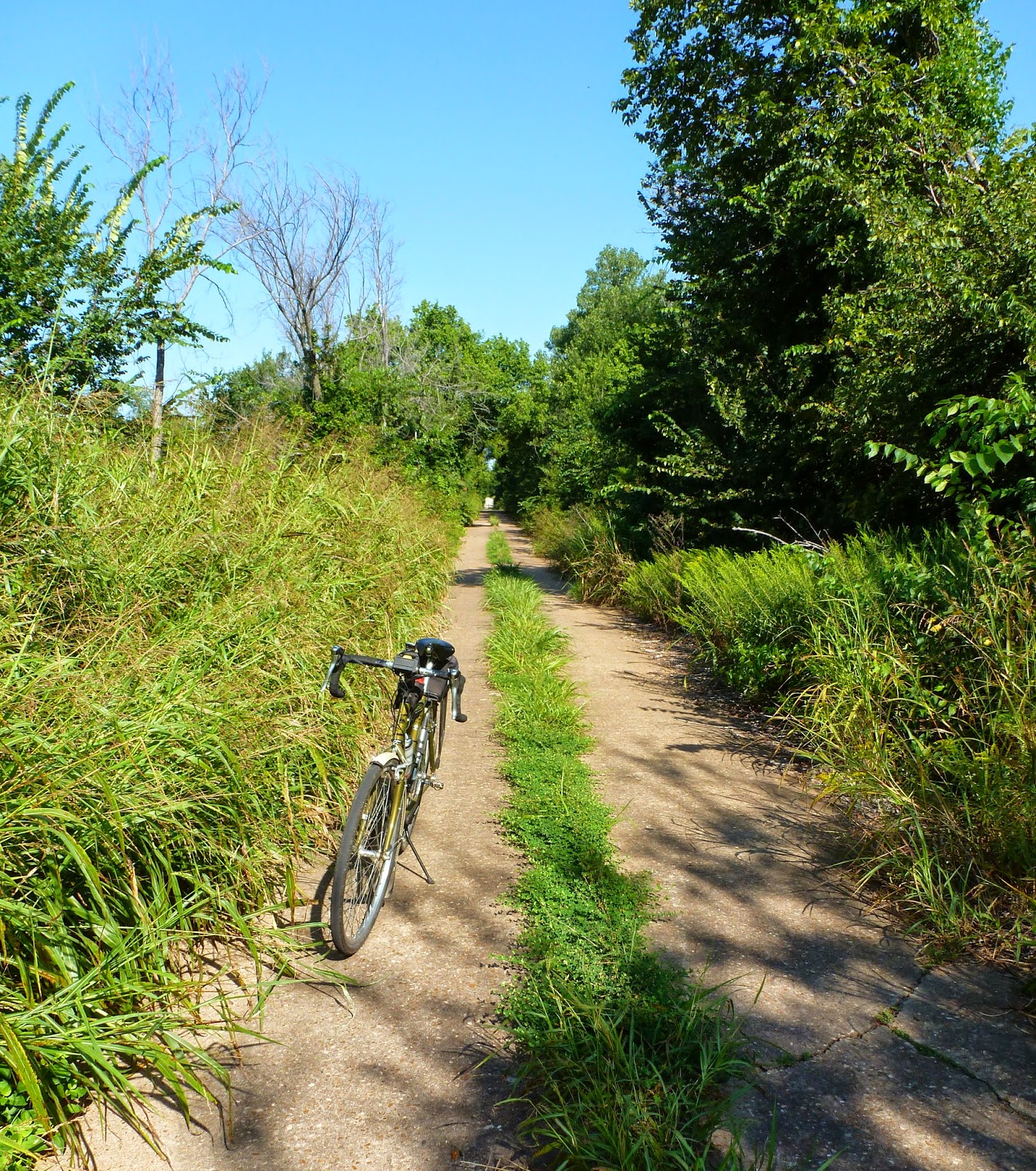


This old road came to my attention from the remarks of a long time resident. The road itself was a remnant of U.S. Highway 62, now bypassed by a more modern highway, but here and there a small section of original road remains. This one led back to an old riveted iron bridge most likely from the 1930's. I might never have found this if not for my bicycle as it is not the kind of road you would want to travel down in a car.


The bridge allowed the road to pass over this little creek far below.


So many of these old highways and bridges and even towns are disappearing because they have been bypassed by the big red and yellow lines, and people who are in too much of a hurry to get where they are going. Not too many of the local people even are aware of this road.

Then, there are the thin gray lines, and the double dashed lines, the ones that are usually not paved. These are the ones that define the meaning of adventure! It's what adventure bikes are built for. Gravelled roads, but sometimes only dirt, not even worthy of a "secondary road" designation. The "Third World" of roads. It is these roads where you can find the most wonderful sights. Like the early morning sun streaming through the trees.


The roads stretch on, not connecting towns, but instead, connecting farms and people.


 Bringing together the local people along these roads, like this country church, is part of the function of these small gravel roads. In this case, a restoration of an old one room country school into a local church, many miles from town is a way to bring the farming and ranching community closer together. I felt, a much better use for the old country schoolhouse than just letting it rot away unused.


There are times, however, when I begin to doubt the wisdom of my choice of roads. This one with it's soft, loose gravel was not one of my better choices. Still, with a sturdy framed bike designed for this type of riding, some low gears, and wide tires with a tread designed to handle loose surfaces, it was entirely manageable. My definition of an adventure bike is one just like this one.


There are times, out here in the wilderness, when the locals look at you like they've never seen another living soul. Like these three curious critters.


Wildflowers have been prolific this year.


Once in a while, one stumbles across something unique that is rarely seen anymore. Like this early 50's Hudson.


Or ....as I like to call these .... "Mechanical Politicians" .... disseminators of bull sh*t, or in more acceptable terms a "manure spreader", an organic field fertilizing machine.


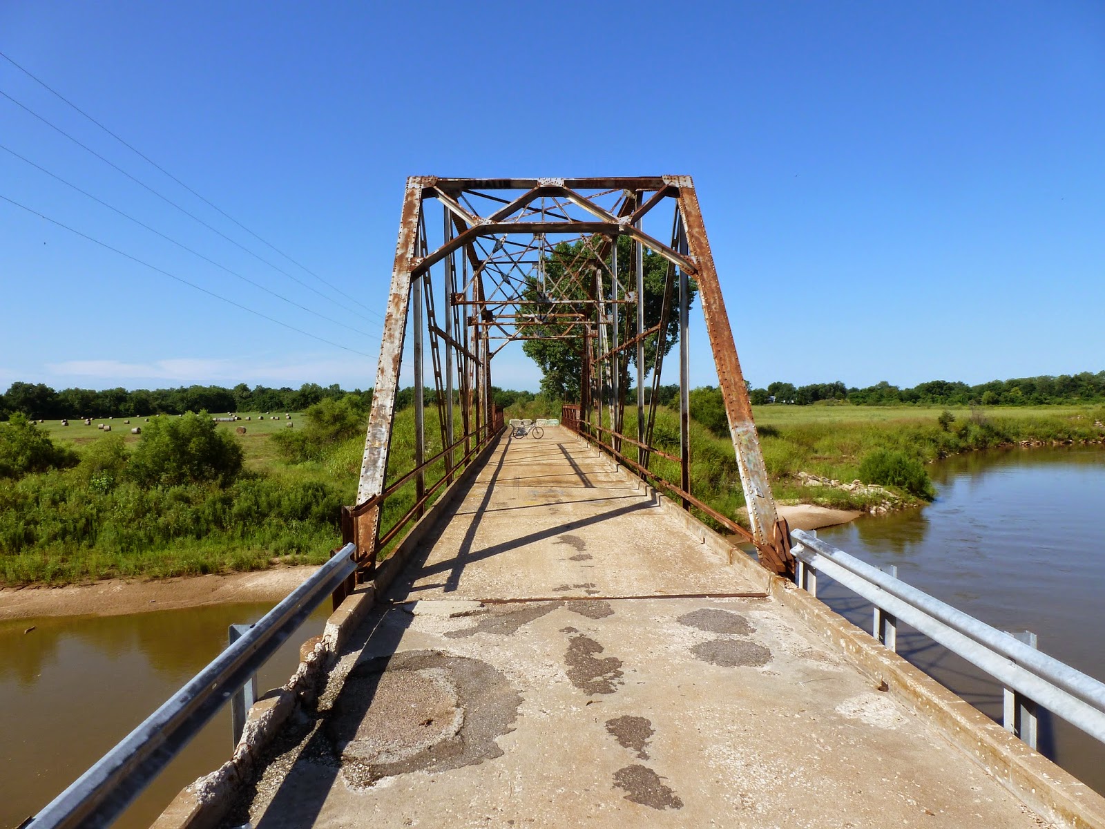
This used to be one of our most wonderful bicycling roads until the City of Shawnee closed it off a few years ago. It seems the old iron bridge on this road was condemned by the State Highway Department, so they just closed it off instead of repairing it. There are several ways around. Our club has been negotiating with the city to convert it into a bicycle and pedestrian path, and they have gotten so far as to install bypass bollards out on the road.
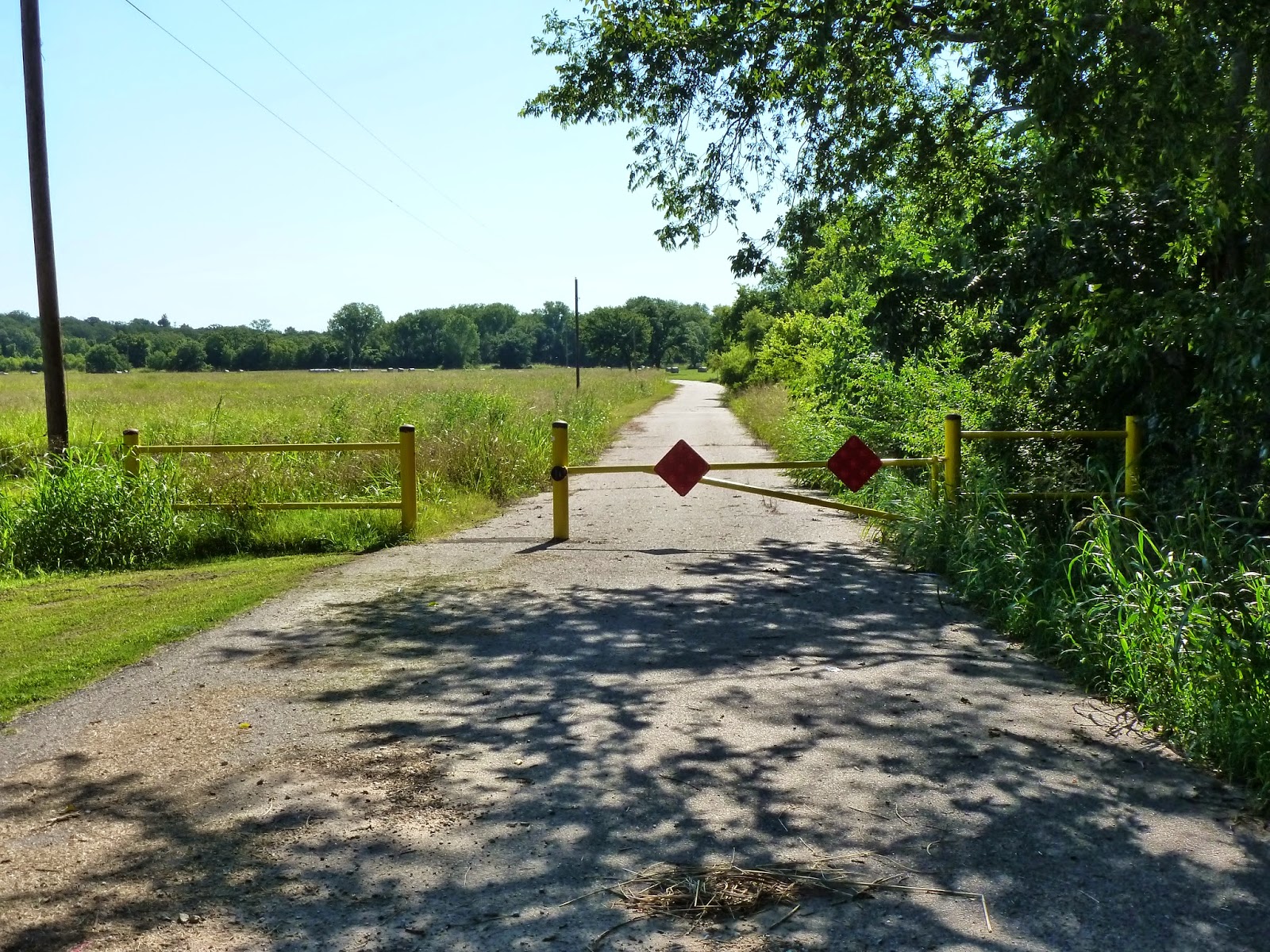


They have not, however, gotten around to providing access through the steel barrier and earthen berms that keep the curious from the bridge. This is entirely off limits to auto drivers, as the initial barricades are a half mile from the bridge. For me though, it was just pick up the bike, and lift it over the barricade and carry it over the berm ..... and here I am!


The bridge itself is still in very usable shape, at least for light use. The problem that closed it was that the concrete curbing's on the bridge edge and parts of the concrete paving was breaking up, however, the steel structure was still sound, and the paving easily would accommodate bicycles and pedestrians for many, many decades to come.


Another nifty old iron bridge! This one was initially a double span like the one I'm standing under, but part of it washed away and was replaced by the low truss that you can see a part of at the edge of the picture, making this bridge a bit unique. The bridge spans the North Canadian River just south of Shawnee.


On the picture below, one can see the damage to the roadway.


On some roads, one finds bridges that are truly not seen hardly  anywhere anymore. This one was not only wooden on top, but held up, not by steel beams, but by large timbers under the bridge. There was a weight limit of two tons. Still in everyday use.


Then, off on another road at another time, is the ghost town of Ingalls, Oklahoma. The scene of a 19th century shootout between several U.S. marshals and members of the Doolin Gang. The outcome was one killed and two wounded after several hours and several hundred rounds fired. At one time, This town was an important little city in growing Payne County, on the railroad and destined to become an important trade center. The railroad fizzled, and Stillwater, which had the Santa Fe Railroad, became the major town instead. Today, this is all that is left of Ingalls, a few decaying buildings on one of the thin gray lines about 9 miles east of Stillwater, Oklahoma.


The next series of photos was from another blog post entitled "The Gold Belt Tour" from September of 2012. I thought it fit in well here because of the wonderful jeep trail in the Rockies that took me through history as well as a wonderful adventure. A ride that one would have difficulty negotiating with a car or a road bike. One sign said 4 wheel drive and high clearance recommended. I might add some very low gearing helpful in a few places. This ride was one that will stay in my mind forever. "Hole In The Rock", below.


If you wanted to see the rest of the write up on this Gold Belt Tour, use the archive and go to September 2012 to find it. It was indeed a fun ride. The purpose of this post was to instill a bit of adventure spirit in my bicycling readers to get off the blue,black, red and yellow lines, and seek out the thin gray lines where you might find anything ..... even a bit of local color like that below.


Monday, June 30, 2014

Why Not!


Monday, June 30, 2014:

The last day of the month of June. June having in it the first day of summer, the start of the hot season.  June is also one of the four months with only 30 days. Not a particularly good month for anything particular, certainly not for going after big monthly bicycle mileage .... it's a day short. If I was going to do that, I'd certainly have picked one of the 31 day months. I finished up my ride yesterday .... the day before the last day of the month with 772 miles total for the month. The only reason for that many was the 365 miles I had put on while doing the Prairie Spirit Trail and the Katy Trail this month. 772 miles, and the next to the last day of the month of June ..... most people would have looked at that and been more than satisfied. For me ..... it's not any record, I've had two months with over 1000 miles since I've been keeping track with a bike log, and a couple more with 900, so nothing special really, not even for a 30 day month. So really, I should have been pretty happy with this accomplishment, after all, how many people actually ride a bike 772 miles in any month .... really? Plus, the weather forecast was for a windy day today, and very muggy, not exactly the kind of weather I like to ride in. For once, the weather forecaster got it right. Winds right up there at 16-18mph and gusty at 6am this morning, from the south, and hydrating would be no problem ....... you would inhale a 20 ounce bottle of water an hour just with the air you breathed. So, at 6am, I walked outside, and felt the wind pushing me, looked up and saw the stiff old oak trees bend over at the top, and said that this, this day would be a great day to do some indoor bike maintenance. The cat tried to follow me out to the shop, and got blown sideways under my pickup, finally gave up and headed back for the safeness and serenity of the garage. I puttered around, and cleaned a chain, swapped out the stock saddle on my gravel bike for a Fizik Rondine that I had, and I remembered was a pretty good saddle. I had the Rondine on my touring bike for a while. After 365 miles in a week on the stock Cannondale Quick saddle left me thinking I needed something a bit different to try. Why buy something new if you have something here to try. So, I switched it out and I'll give that one a try one of these days.

772 miles ...... WHY is this working on me so much. It's a good number....... NO it's not! It's too short! It's only 28 miles short of being 800. Why is 800 a great number ...... I don't know ..... maybe because it's not 772, a number too short by 28. Alright, wind or no wind ...... I'm riding! Go in the house, change my clothes, grab a full 25 ounce water bottle, and head out the door and down to the shop. Hmmmmmm .... the wind seems even stronger now, no, it's just my imagination, really, back to the house, look at the wind gauge on the computer, yep ..... 18-20mph now, it IS a little stronger. Okay, I'll settle for 772 ...... back to the house, pour another cup of coffee ........ Like HELL am I gonna settle for 772, a number too short by 28. Stomp back out to the shop, grab my helmet, stick the water bottle on the bike, and left .... left .......as in leaning over to the left trying to stay upright. I'm going to do this, I AM!!! Turned north and headed for the main road. WHOA!!! hardly pedaling and I'm cruising along at 16, this isn't so bad. Hey, dummy ...... you are sooner or later going to have to go the other way, you know? So, finally, out on the road, and now I'm not turning back. Got out, finished a 32 mile ride, drenched in sweat from head to toe, running down through my eyes and burning as it did, cycling kit that I could wring the water out. 32 hilly miles, angry at myself for all the procrastination, meant that I pushed myself harder than normal, but I finished that 32 mile ride, and did it with a 15.4 average speed. 804 miles for the month, was not a new record for me, but it was the highest mileage month this year, and while 15.4mph average isn't a new record either, I thought it pretty good for a blustery day. In the end, I felt good, drenched in sweat, water bottle empty, muscles sore all over, hot, achy, and brimming with accomplishment. Hmmmmm  ......804 miles .....is this going to work on me ...... HELL NO!!!! I'm satisfied!

Monday, June 23, 2014

Katy Trail 2014, Day 6


Friday;

Sedalia to Clinton, 39 miles;

Another short day, and our last on the trail. Many have the return bus trip to Columbia and St Charles to make, and a shorter trail day makes it possible. More headwinds today ...... would there be any doubt? Relatively flat day today with just a couple of long up and down gentle grades, BUT ........ we did reach the highest point on the trail at an oxygen depriving 955 feet above sea level. Gasping for breath, I managed to pedal right on by the sign this year without having to stop .... the next 30 miles is all downhill ..... just kidding ..... no it's not, plus we got a headwind.

A few pretty wildflowers along the way to brighten my morning.


Rob came up and took the lead from me for a while and relieved some of the pressure of having to fight the wind the rest of the way to Clinton. Before you knew it, here we are at the Clinton Trailhead.


Before long, Kelley and Jim showed up, and here is the four of us, Conquerors of the Trail! For Kelley and Rob and I, the end of our second trip, once each direction, for Jim, he can no longer say that he's always wanted to do this ..... because he did! Having ridden this trail in both directions, I can honestly say, that the west to east direction is a bit easier, not because it's downhill, but because of the constant headwind on the east to west. But, you just gotta do it both ways and find out for yourself.
Here's the four Bikesateers, after conquering the Katy, and in the toughest direction .... finished! At the Clinton Trailhead, at last.


The end of the trail is always so bittersweet to me, it means I accomplished what I had set out to do, but after all the trials and tribulations, all the fun and enjoyment and food and drink and laughs and all that we shared together, it means saying goodbye to our friends and heading our separate ways to our homes once again. I'm going to miss all of you! I probably won't miss the bug bites, rashes, and sunburned nose too much, but, hey, it's all part of the deal.

They served us lunch today, and I gathered up my bags, carried them one more time and put them in my car, got a shower, said all my goodbyes, and left for the six hour trip home. About an hour out of Clinton, my phone rang .... startled me, I picked it up and answered ...... it was the tour director asking me if I had made it off the trail okay today. In all the excitement of finishing and all the goodbyes, and thinking about the fact the ride is finished, and leaving for home .... I had forgotten to check in at the information booth. If he could have seen me over the phone, he'd have seen my blush.  So they called to make sure I was alright. See, these people even watch over you even after the ride. What a great bunch of people to ride with. This was another absolutely great ride on the Katy Trail, it's just no wonder it is  The premier trail to ride in the country, it's definitely a gotta-do. Once again, I'll state here, that you can do it yourself, but why would you want to when you can be pampered and taken care of all the way across, AND, make wonderful friends as a bonus, for just about the same amount of money and time involved. Me, I'll do it with the State Parks any ol' time! Plus, you get all this neat schwag ....


Several years ago, my friend Lydia and I did a Route 66 ride across Arizona, and she bought me my first hat pin. this has started a small collection since then for special rides, and, at the depot in Sedalia, I found the perfect one.


And so ends another ride on the Katy..... Loved the ride, the people, and the fun and good times. Do it!


Sunday, June 22, 2014

Katy Trail 2014, Day Five


Thursday;
 
Boonville to Sedalia,
 
After our dinner in downtown Boonville, we decided to walk back to the campground. It seemed a good excuse to find an ice cream shop. The one we wanted was, of course, closed, but we did find a Dairy Queen which was open. I also found this cool art-deco bicycle. 


When we arrived back at camp, we found that the town of Boonville provided us with entertainment in the form of a baseball game!  
 

The next morning, we were up and at 'em early, ate pancakes and sausage, and fresh fruit with the Pancake Man. Then hit the trail. A rather uneventful morning so far except for the everyday headwind. Headed for Pilot Grove we noticed a large group of bicyclists gathered around a bike with apparent tire problems. There was quite a few riders there, so I felt they didn't need us. Later, at the Pilot Grove rest stop, Kathy told me that the tire, or wheel problems were not fixable there, so the Park Ranger showed up, gave his bike to the lady with the problem and let her ride to the next stop, while he pushed her bike and called for our roving bike shop to meet them for a fix. How about that for taking care of riders, and dedication to duty. The Rangers were always with us, riding the trails, and watching over us all night long keeping us and our camp as well as our gear safe. What a great privilege to ride this route with such a great bunch of people in charge.

I met this Ranger coming at me across the bridge.


Pilot Grove rest stop and trailhead.


The country changes on this section of the trail as we move away from the river. The trail is actually quite hilly all the way now to Clinton, with long gentle up and downgrades. The countryside is also more farming country with corn and wheat and hay fields.


At the top of one of the long upgrades we usually had a cut through the limestone to mark it. Then we could boogie for the next few miles.


I noticed this little footpath leading up and away from the trail, so I got off the bike to see where it went.


And where it went was here ....... a unique little Eco-structure all it's own, looking like it would be more in place in the mountains than here in Missouri. People tell me that there are some words spelled out up here with rocks that can be seen after hiking up to the top of yonder limestone cliffs, but I never found out. They also said you can see the words from space ...... I never found that out either. I did, however find a very pretty area and didn't regret the hike at all.


I also found this pretty yucca in full bloom just to add to my good fortune.


Back on the trail, I was fortunate enough to capture a rider going by the only surviving signal light on the entire trail.


The top of another upgrade


Just before we got to Clifton City, there was an Amish family selling home-made cookies and lemonade alongside the trail. They wouldn't let me take their pictures, but they would let me buy their cookies, and they were very good. Downtown Clifton City could use a bit of renovation.


The old buildings and overgrown ditches did allow for some unique photos though.


And the top of yet another hill ......


Hilltops alternating with farmland, alternating with tree canopy.


A short but hilly and windy 37 mile day brought us to Sedalia and their wonderfully restored depot, bike shop, food vendors, and museum. A good place to kill an hour or so before heading for the park. It was still early, a bit before noon.


More Ranger presence walking through the camp checking on everyone. There is always a Ranger with this ride from the beginning to the end 24 hours a day. When you ride with the State Park Trail Ride, they think of everything, and take care of you like one big happy family. In fact by this time, all of us were thinking we were like one big happy family.


There is a live steamer and track around the park, and they brought it out for a ride around the park. Does this engineer look like he's having fun, or what?


We had lots of time to kill before dinner, which would be served "in house" tonight. I had plenty of time to ride downtown for a Guinness on tap, and ride back for a circuitous route through town to admire the many pretty old houses and fine downtown architecture. I covered a few miles, and thoroughly enjoyed a couple hour ride. 


Dinner tonight was excellent! Bar-b-que brisket, roast turkey, baked potato, fruit, and a wonderful dessert. We shouldn't need to find ice cream tonight. After dinner, we had our riders meeting which ended with our group photo just before sundown.
As I said before, we were by now, one big happy family. This is Kathy and Becky, two of my friends from last year's ride, and even better friends after this ride. Such nice gals, both of them.


It wasn't long after this that darkness descended on us, and I turned in to prepare for our last day on the trail. Tomorrow will be another short 39 mile day.

Katy Trail 2014 Day Four


Wednesday;

Another 50 miles day today, from Jefferson City to Boonville. Saw a few things along the trail I hadn't seen the last time through. One, at least, by accident.  Up at 5am and packed up, took our gear to the trucks and rode a few miles to breakfast. We were hungry when we got there. The pancake man was there with french toast, sausage, and fresh cut fruit ..... yum! The local TV station was also taking video of us coming down the new bridge ramp, and at breakfast, and of course, the Pancake Man put on a bit of a show for them. He is such a showman, with a personality that won't stop.
I think it's impossible to go across the Jefferson City Bridge without stopping for a picture of the Capitol, especially in the early morning light.


Breakfast with the Pancake Man!


Restricted Parking ....... that means no cars, bikes only, right? Works for me!


Kelley and Rob leaving out ahead of me in the morning light with looonngg shadows.


Another early morning shot of a pretty farm right along the trail, and freshly mowed hay.


I know everyone has heard of the Cadillac Ranch, this must be the "Boat-au-Lac" ranch.


"For sale, in quaint Missouri town. Small town charm, quality built solid brick home with fireplace and front porch. One owner with many unique features including a comfy front porch chaise. Beautiful shade trees in back, and overlooking the Katy Trail with instant access, reduced price on this unique home if you buy today"


Last time around I looked for the "Old Burr Oak", a tree that is estimated to be around 375 years old, and thanks to good directions from Kathy, this time I found it. It's about a quarter mile off the trail, and even from a distance it's impressive. If you compare the trunk to my bike, you can see that it's probably close to 12 feet in diameter. Still very healthy looking, it was already an old tree when Lewis and Clark came by. Quite an amazing sight.


I didn't want it to fall over while I was there, so I thought I'd hold it up for a bit.


This area is noted for towering limestone cliffs on one side of the trail, and trees and the river on the other side. A very pretty area to ride through. The scenery changes constantly as you ride the trail, from one end to the other, so it's very hard to get bored.


A little break waiting for the others to catch up. A pretty little bench overlooking the river, time for a little rest and ....
 

A little snack! Grabbed an extra bag of freshly made granola from the last rest stop, it was delicious, so I ate it all!


Before long we were in Rocheport, and this is the Main street. As you can see, the flag is standing out to the east from the pole. A reminder that we have had headwinds every single solitary day this week. All the bikes you see are at the Rocheport General Store, a good place to eat and drink along the trail. We decided to push on to Boonville, however and eat lunch there as it was only 10:30am here.


Rocheport of course is famous for having the only tunnel on the Katy Trail, and here is yours truly exiting the tunnel. Picture courtesy of Kelley.


New Franklin, Missouri, is known as the Mother of the Santa Fe Trail. The monument here depicts early pioneers along the trail. This must be new as it is right on the trail and I never saw it before. Some beautiful art work etched on polished granite. I only wish my camera would have picked it up better.


I've known there was a campground in Franklin called the Katy Roundhouse, but always thought they were just using the name.


But then ..... I found this ...... an original engine turntable, not in the best of shape anymore, but still holding together well enough to tell what it was. I didn't find any actual roundhouse to go with the turntable, but it had to be right here with it.  This, I never knew was here either. See what you find when you venture off the trail even just a little ways?


We rode the short distance from Franklin to Boonville and into town across the dedicated protected bike lane on the bridge over the river. At the bottom, we stopped at the restaurant where we were planning on eating only to find a "closed" sign. I swear, this luck is going to follow us everywhere. fortunately, Boonville has several restaurants, and just up the street was a nice little place where I had a salad from a very fresh, nicely stocked salad bar. Something cold just hit the spot. We then headed to the park and set up camp for another night. I think I must have set up a bit too close to the woods as I ended up with some very itchy insect bites to go along with my red ankle rash. Oh well, tent camping isn't for the timid.


Dinner here was another $10 Boonville Bucks check, and a bus trip into town. We did find a restaurant that had good food and was a bit trendy and atmospheric, and the food was good, although I think when it said "special menu and pricing for Katy Trail riders", what that really meant was that they doubled their normal prices just for us. The ten dollar check helped though, and the food and drink was good. A quiet night and a good nights sleep, and I never knew about the new bites until after we got going in the morning. Ah me, burned nose, rashy ankles, itchy bites...... it's all part of the experience.