Monday, November 28, 2011

Route 66, Up Sitgreaves Pass

Today is the day I try to catch up on the finish of the Kingman Route 66 ride. We started out in Kingman, AZ on this leg, and worked our way west on the old part of Rt 66 up toward the old gold and siver mining town of Oatman, Az. First, however, there is the advent of a little hill called Sitgreaves Pass to take up a bit of our energy. The scenery on this part of old 66 is far different from the route north of Kingman, definitely much more mountainous, both in terrain as well as wildlife.


The area is not only much more rugged, but also much more colorful as well. The first several miles that we traveled on this route were fresh chip-seal, still loose and challenging to ride on. This part of the ride would have been better to do with mountain bikes. This was very recently done however, but what was even worse was that they had gone ahead of the chip seal operation and sealed all the cracks first with tar and produced a very rough surface for us. On backsides that were still a bit tender from the long ride to Seligman the day before, the jarring from the hardened tar fillings definitely were noticed. After a little less than five miles however, this was gone, and the old highway was still in good shape as we started up the grade. The monolith above was prominent from a considerable distance, and the overcast skies just made the desert even more beautiful as we worked our way up.


We soon found ourselves climbing vigorously as we tackled the beginnings of the long grade up to the summit. Time constraints would limit us to a round trip to the summit today because my riding companion had to start back by early afternoon in order to return to work the next day. About halfway up the hill, and about the part where the REAL climbing was about to commence, there stood a relic from the past ..... now turned gift shop, and "sorta-museum".....


Ran by a character by the name of George, who was as interesting ....... and as unusual as the place iteself. They offered free water, and welcome outhouses (very clean by the way), and we ended up spending at least a half hour there talking and looking at all the interesting things he had on display inside and out. Very worthwhile stop for anyone going up that way, by bike, or car. While we were looking around the outside we were paid a visit by one of the "locals"......


He was not only a character with a personality all his own, but a bit of a mooch as well. Certainly very photogenic however. From here, it was going to take a bit longer to get to the top however as the road became much steeper, narrower, and much more wild as we progressed up. Lydia led the way as we left the gift shop/ gas station.


There was still another 5 miles to go before we could reach the summit. The weather turned out to be absolutely a perfect day for riding after the morning clouds burned off. The wind was almost non existant, and the scenery spectacular. As we were climbing we kept hearing these strange noises coming from up ahead, and finally found what was making them.......


The Jack was not only protecting his Jenny, but also the rest of his "family as well, Unfortunately, the little one was pretty quick to follow on his mom's heels and never really presented me with a good shot, this was about the only one I got with him in it.
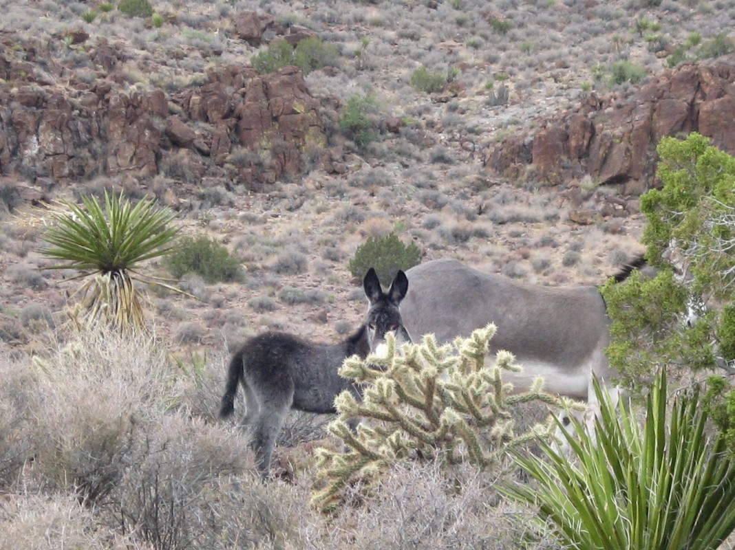
He was such a cute little tyke, but our presence made both Mom and Dad somewhat nervous. These burros are wild creatures, relatives of the many domesticated burros the prospectors used to carry their tools and equipment up to the mines in the 1800's. When the mines played out after a few years, the miners left, and just left the burros behind. They flourished in the hills and now are a fairly common sight.


After our photo session with some of the local "wildlife" of unusual origins, we made a turn in the road, and came upon a sight not viewed by many.


An entire flock of Desert Bighorns. They are actually fairly common to this area, but are seldom seen because they are normally quite wary. This was a long telephoto shot as we could get no closer and they were across the canyon from us. I was wishing for a bit longer tele capacity on my camera about then however.


We found that soon they were bored with us and moved on around the corner of the canyon they were grazing on, and out of sight. We climbed on up to another vantage point but were unable to get another picture of them. I did, however get a great picture of some of the better scenery of our ride.


The further up we went, the more spectacular the scenery became, and the more twisty and steep the road became.


Certainly a bit of a challenge for a morning's ride. We did, however, prove ourselves up to the challenge .......


And....soon found ourselves at the summit....


Going back down was quick, fun, and uneventful. We were back at Kingman in a short time, and unfortunately, the weekend had to come to a close as we had to head our separate ways to return to our homes and jobs. Much fun, and such an enjoyable time exploring a very historical area of our country. We both vowed to continue this at a later date.

Saturday, November 26, 2011

A Route 66 Odyssey

I had been wanting to try a Route 66 ride in Arizona for some time. I had managed a little bit of it a year earlier, and it whet my appetite for more. Logistics was the problem ..... I just really didn't want to ride the whole thing twice to get back to my car. So, I called a good friend of mine to see if she wanted to ride it with me. She did! So, we set a date, and met and based in Kingman, AZ, leapfrogged cars to each end and kept one in Kingman. That way, we only had to ride the route once, and took the waiting car back. Worked out OK....a bit of driving, but we took a different route and saw a little different scenery on the way. This ride is an older ride, completed in October, 2009, but with some great memories. October is a great time of year to ride northern Arizona, the temperatures are rather cool in the morning, but warm up nicely by late morning and afternoon. A light jacket would have felt good when we left Kingman that morning, but I hate to stuff it in my back pocket, sooooo I toughed it out.  The sign says it all......


 although we never made it all the way to Flagstaff, there'll be another trip, and that time we will make enough time for a long trip. Just didn't have any room on our road bikes for luggage, and work constraints made the time impossible for us to complete that long a trip, so, we took it in two legs. Leg one..... Kingman to Seligman, 85 miles, ...... leg two..... Kingman to the top of Sitgreaves Pass and return, around 40 miles.

Flat the first little part of the ride, but subtly uphill really all the way. Around 3000 feet at Kingman, but 5400 feet before Seligman. This was our first real taste of seeing how well either of us would perform at any kind of elevation. The first thing we noticed was the road surface..... a chip seal, very rough, and draggy. So...we white lined it almost all the way. After we left Hackberry, we had very little traffic to contend with. so it really wasn't bad riding the white line. People seemed very polite and gave us plenty of room. After leaving Hackberry, we found that there was indeed a few actual hills on our route.....


We finally made our way on up and over and discovered an old tourist trap from the 30's or so. There may have been a name for this place, but I can't recall it. Really a cool place with lots of old stuff from the 30's, 40's and 50's. I'm sure if the place could talk, it would have a million stories to tell. Instead, it allowed us to read our own from what we saw there.


After we left the "museum" as such, we once again started a steady uphill grade that continued on and off all the way to Peach Springs.


Just a little ways over this little hill we came across this old "cable" drilling rig. Not too many of these around, even for viewing. I doubt if there are any in operating condition.


A little past here was a pretty little ranch nestled in this little valley. We were both impressed at how green the desert was in October.


And a few tenacious desert plants.


Continuing on, we finally made it into the town of Peach Springs, a milestone in as this was past the point of no return. Fifty miles into the ride, it was closer to Seligman now than it was to go back to Kingman. Not too much there, but we took a short break, ate a snack, and rested up a bit.


Peach Springs is an Indian Tribal headquarters, and they did have a large governmental facility there as well. There was a little store to grab a snack before heading out. Leaving Peach Springs is a rather long and steep climb, but after topping out, there were great desert views of wide open spaces.


After a bunch of miles of this, we finally came upon Grand Canyon Caverns. Another tourist stop from days of old. After the Interstate bypassed this route, most of these little places died along the way. This one did, however, hang on. Boasting a campground, general store, mini-museum, and a whole lot of history, we stopped for a break here and did a little sight-seeing ourselves. One of the first things I noticed was this ancient switchboard .....


Not something you see every day anymore. We sat down outside on a bench with the old "Route 66" sign for a tourist picture....courtesy of self timer on my camera.


They even had their own antique fire truck....still in operating condition.


For those of you with more time than we had, they do have guided jeep tours of the caverns that are up the road a piece from the crossroads. Before leaving....and if I didn't mention it here, I'd never hear the end of it..... I managed to sneak in a HUGE ice cream cone...... it was GREAT!
Leaving there, and on our final leg to Seligman, I did indeed find a sight reminicent of the heyday of "Route 66". It's been a long time since I've seen Burma Shave signs, and Lydia had never seen one.... indeed, didn't even know about them, this was a whole new experience for her. Had to get the whole sequence.


I recall those signs all over the country, always with a different slogan, and used to enjoy reading them all when I was a kid. These, while not original, surely brought back wonderful memories, and I'm glad they restored them and put them out there. Always, all along the route, we were never far from our constant companion..... The Santa Fe..........


Finally, topping out, it was now downhill the next 8 miles into Seligman.....I knew we were going to make it. By now though, we were both getting a bit tired, and saddle weary.


And FINALLY....... we had to make sure and get the touristy pictures here, completing our epic one day journey up Rt 66.   Seligman....at last........


Venturing on downtown, we found the normal Rt 66 traffic to be almost unbearable while we stood in the middle of the busy highway trying to decide where to go next.......


Touring the old town on our bikes was indeed fun, and an enjoyable ending to our wonderful trip.


Of course, I couldn't help but ham it up a bit.....


And, so, another chapter brought to a close. We found my car, put the bikes on the carrier, and drove back to Kingman, where we enjoyed a dinner at the Golden Corral, one of my favorite eateries. The next installment on our "great Rt 66 Adventure" will come as a separate post as this one has already gone on too long. 

Monday, November 21, 2011

A Shakedown Cruise

Well, my first real loaded tour with my new Cannondale T2 touring bike. How did it go..... in a word....GREAT!


Had the bike loaded a bit heavier than I wanted, bike, gear and all was right at 73 pounds as it sits right there without water bottles. I didn't weigh it after I added the bottles. I took off about ten minutes after I took this picture into an ever increasing 15mph (later to be 20+) headwind. Leave it to me to pick a direction where I'd have a headwind all the way. My destination was Clear Bay at Lake Thunderbird State Park, in the city limits of Norman, OK. This would have been about a 42 mile ride, if that had been the way it went, but that adventure will come later.
By the time I had gotten to Bethel Store..... 17 miles from the house, I was already getting a bit disgusted by the strong wind. I decided to take a break and time for a snack, and a few photos. Dug out my little mini-pod and set my camera up for a couple of self portraits.


Our typical eastern Oklahoma hills urged me on. between the hills and the headwind, it was a struggle to maintain any kind of forward momentum.


There were places where the Fall color was still in evidence.


Finally arriving at Highway 9, and turning west, I knew I had to complete it now, as I was already more than half way. So, after an epic struggle into the wind all day, I arrived at my destination.


Turning north at the sign and riding three miles into the park brought me to the sign that said "Tent Camping Area closed for the season"..... WHAT!!! Well, lets go on a bit, as there was another campground up here a little ways. Yes there was..... a full-hookup RV park.... no tents allowed. The nice lady there told me to go to Little Axe campground..... back the way I came about seven miles. , so....out I went and back to Little Axe, traverssing a bit of country road to get there.....


And...when I did....what do you suppose I found? Another sign across a locked gate that said... "Campground closed for renovation after tornado" Oh Great! So....I sat there scratching my helmet and wondering what to do next...... I mean, I was tired, it was getting a little late in the day to be searching much further ....... and about then a pickup comes up, the driver leaning out and asking if I might be lost. Well, no, I'm not really lost, but certainly could use a little help. After explaining what I had gone through so far...... he directed me on to Post Oak Campground. So....two miles back out to the main road, three miles north, and two miles back into the campground, I found another RV campground. This one however, not quite so fancy. They would let me camp there, but I had to pay a RV rate. After chatting with them a bit, they agreed to a lower rate, and a senior discount, so I took it. Fifty-three miles into the ride, I had a camping spot. And what a camping spot it turned out to be. Had it almost to myself. There was only one other camper in the place, and it was absolutely beautiful.


Picking out a good campsite proved to be problematic..... there were too many to choose from! They all looked great, and so, finally I picked one and started setting up camp.


While I was busy setting up camp....I realized I was NOT alone after all. I had a supervisor on the job. Obviously NOT a fat-cat goverment big wig, but just an ordinary girl watching to make sure I did it all right.....


After making my aquaintence, she proceeded to help me with getting everything else ready, and paying particular attention to the kitchen stuff. You got food? I told her I wasn't quite ready to fix dinner yet, but she was patient and she'd wait. So, went and took a nice HOT shower and found they had been thoughtful enough to install a shower massage unit in the shower...... I didn't want to leave. I'd just let it pound on my back forever. But....I wanted to get started cooking before it got too dark. By now, there were two feline friends waiting for my return. Both very hungry. So, setting up a pannier to block the wind, I lit my little stove and prepared a meal fit for a king..... well.....maybe not....but it was really good, and done in about 8 minutes. My little Coleman Micro-stove worked very good, boiling 16 oz of water in about three minutes.


Pouring the boiling water right into the pouch, stirring once, waiting five minutes and stirring again produced a wonderfully smelling meal, ready to eat. So, I tried it......and surprise of surprises.... it was really good. I ate about two thirds of it, dumped some on the concrete, and slit open the bag for the other cat..... and found two kittys that agreed with me, and licked up every bit of what there was. What was nice was that there was very little clean up afterward.
Dinner over, I took a little walk around the campground before it got too dark. Still lots of Fall color here.


The Lake in the background getting a bit washed out in appearance, but that is what that is. Some thought it was snow..... no....just a lake. Walking on a bit further, the sun almost gone now, I found another visitor.....


After a good nights sleep, I was up bright and early, broke camp, and started out amid honking.....


South bound Canada geese making a combacck for the winter. Backtracking the way I came was a bit easier today as there was vitually NO wind. Along the way I found another form of two wheeled art.....


 I bit of Redneck Motor art! Even though there was no wind, I was still hungry..  I fact, by the time I had made 23 miles to Tecumseh, I was REALLY HUNGRY. Pulled into Jewells restaurant (one of my favorites) for a late breakfast After I pigged out on a veggie omelet, I pressed on the remaining 17 miles home. A bit easier day today, and I felt pretty good yet when I got home. So....how did it go....pretty well I'd say. When winter is over, I may have to try another, maybe longer one.

Tuesday, November 8, 2011

Say What?????

Alright......I'm scaring myself now! I find myself researching cross country bicycle routes more and more often. This has to be just a passing thing, and I'm sure I'll come to my senses sooner or later. Still.......maybe a couple of months time involved......... Hmmmmmmm

Friday, November 4, 2011

Draper Mountain Bike Trail, Oklahoma City.

This is a combination of a couple different Oklahoma singletrack trails. I'm not a big mountain biker, but I do on occasion get out and ride the trails for fun. A little later, when I can find the pictures, I'll post one about a little mountain bike excursion in Aztec, New Mexico. But for now, these first pictures are from Draper resevoir east of Oklahoma City. There are a series of four different trails, each one a bit more difficult than the last. They keep adding to them though and making the trails a bit more interesting. If you do the entire four trails it is around 13 miles.
This one makes a wild downhill, and a big grunt uphill with a sharp 90 degree right turn at the very top, the picture does NOT do it justice.


One of the milder parts of the trail, these are what I enjoy the best.


One of the "toys" on the trail, a neat little up and over, down and under bridge. After you go up and over this, you loop around to the right, and come back up under the same bridge. This sort of thing is fun, and keeps the trail interesting.


This is the view from the top of the bridge at the start of the lollipop.


There are lots of areas like this everywhere along this trail, both up and down.


Another one of the new "toys" added.


I think I'll take the long cut around the bottom side thank you. , but the wooden plank bridge on the other side looked like fun, so I did that one.


If you look up at the top of the curve, you can see there is about a one foot drop built in that I didn't know about the first time over ....surprise!!! Still, I had to go around and do it again. Once through this man made part, you were treated to some flat and easy sections before the more technical parts began.


Just a walk in the park....or a ride in the woods. Draper is a fun trail, and not really difficult. An experienced mountain biker can whip it out in about 45 minutes ....  me, about an hour. It is billed as a "family" trail, and I suppose it is, however, I found enough somewhat technical stuff there to make it interesting for a part-time mountain biker. All in all, a nice Sunday afternoon diversion.